May 2011 DEW Attack on Historic Crown Farm Montgomery County Maryland
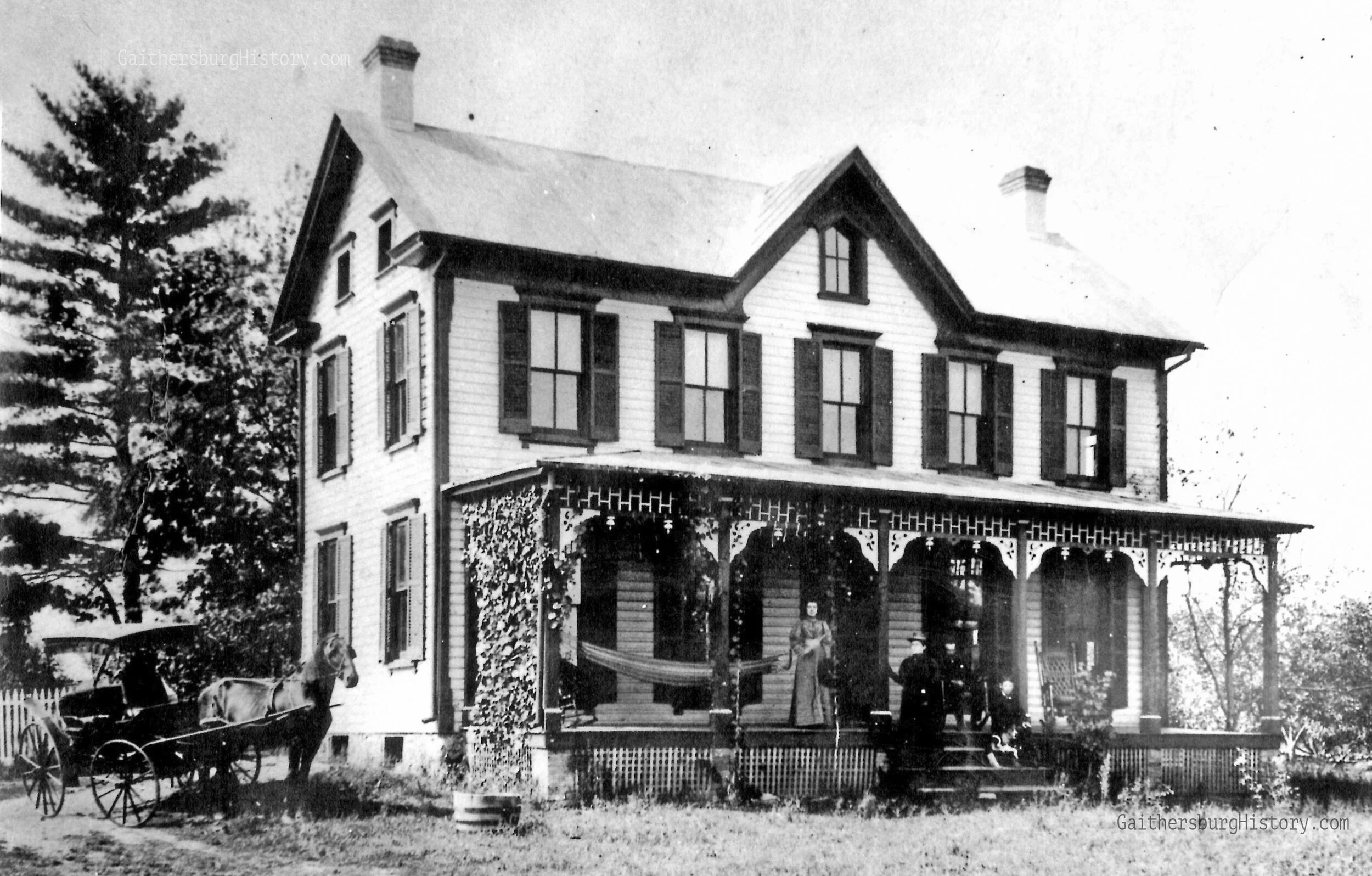
Crown Farm in 1980 — https://www.gaithersburghistory.com/crown-farm-in-1980
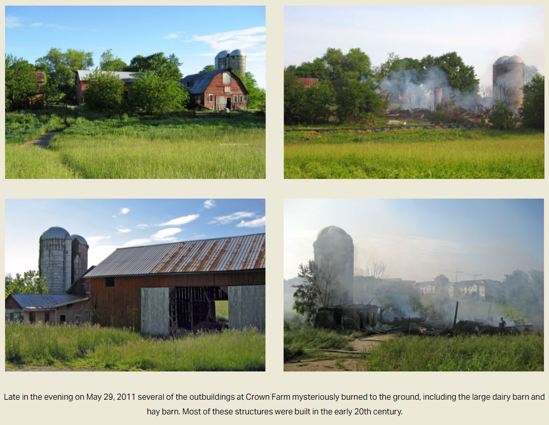
Crown Farm Barn Fire 19 May 2011 — https://www.gaithersburghistory.com/crown-farm-in-1980
Comments left by local residents on the above website most often note suspicion and similarity to suspected DEW Attack that razed Chestnut Lodge in Rockville, Maryland.
Crown Farm, already owned by Montgomery County and yet already on the National Register of Historic Places
Similar evidence and circumstance to other DEW Attacks —
- Raging inferno, fully committing the structures which were uniformly destroyed.
- Numerous firefighters required, tremendous amount of water, much time. DEW few phyres are very difficult to extinguish because their energy source is externally supplied by the microwave energy beam weaponry.
- Greyish / whitish mist, not black sooty smoke. Misting continues long after the phyre is extinguished because it is side-effect of the molecular self-disassociation of the metal materials. This is per HUTCHISON EFFECT. DEW weaponry was introduced in 1983 by President Ronald Reagan as part of his SDI “Star Wars” Strategic Defense Initiative. Huge military contractors have been online at Directed Professionals Society website (https://deps.org) since 1999, years before the 911 event that apparently largely included a DEW Attack, not hiding but openly selling books, classes, memberships.
BELOW: Before and after pictures. Note metal roof. Note whitish / greyish mist not black sooty smoke. The fire had been extinguished since previous 3am. What remains is evidence of “phyre”, a molecular self-disassociation of materials, some of which are off-gassed as mist. This is entirely consistent with the HUTCHISON EFFECT.
Fire at Crown Farm Under Investigation
By Sonya Burke / The Town Courier / May 31, 2011
SOURCE: https://www.gaithersburghistory.com/barn-fire-crown-farm-under-investigation
It took 65 Montgomery County firefighters almost 45 minutes to knock down the bulk of a blaze in a historically designated section of the Crown Farm development site at 9800 Fields Road at 1:23 a.m. on May 30.
Fire Captain Oscar Garcia said when firefighters arrived in the middle of the night a large barn was fully engulfed in flames. He said the 50-feet by 75-feet structure was used for the storage of hay. Several other structures were also damaged.
Assistant City Manager Greg Ossont toured the site on May 31 with staff and said a total of four buildings, including the dairy barn and hay barn, were all destroyed in the Memorial Day fire. Ossont said the concrete silos were also damaged and a structural engineer is being consulted to determine if the silos are in danger of collapse.
According to Garcia, damage is estimated at over $100,000 and the exact cause of the blaze has not been determined.
When the sun came up on Memorial Day, Garcia said fire investigators canvassed the adjacent neighborhoods looking for eyewitnesses. He said officials are asking anyone who might have seen something to call the fire and explosive tip line at 240.777.2263.
“Gaithersburg: Then and Now” author Shaun Curtis visited the site the morning after the fire and he put up some photographs of the aftermath on his website: GaithersburgHistory.com.
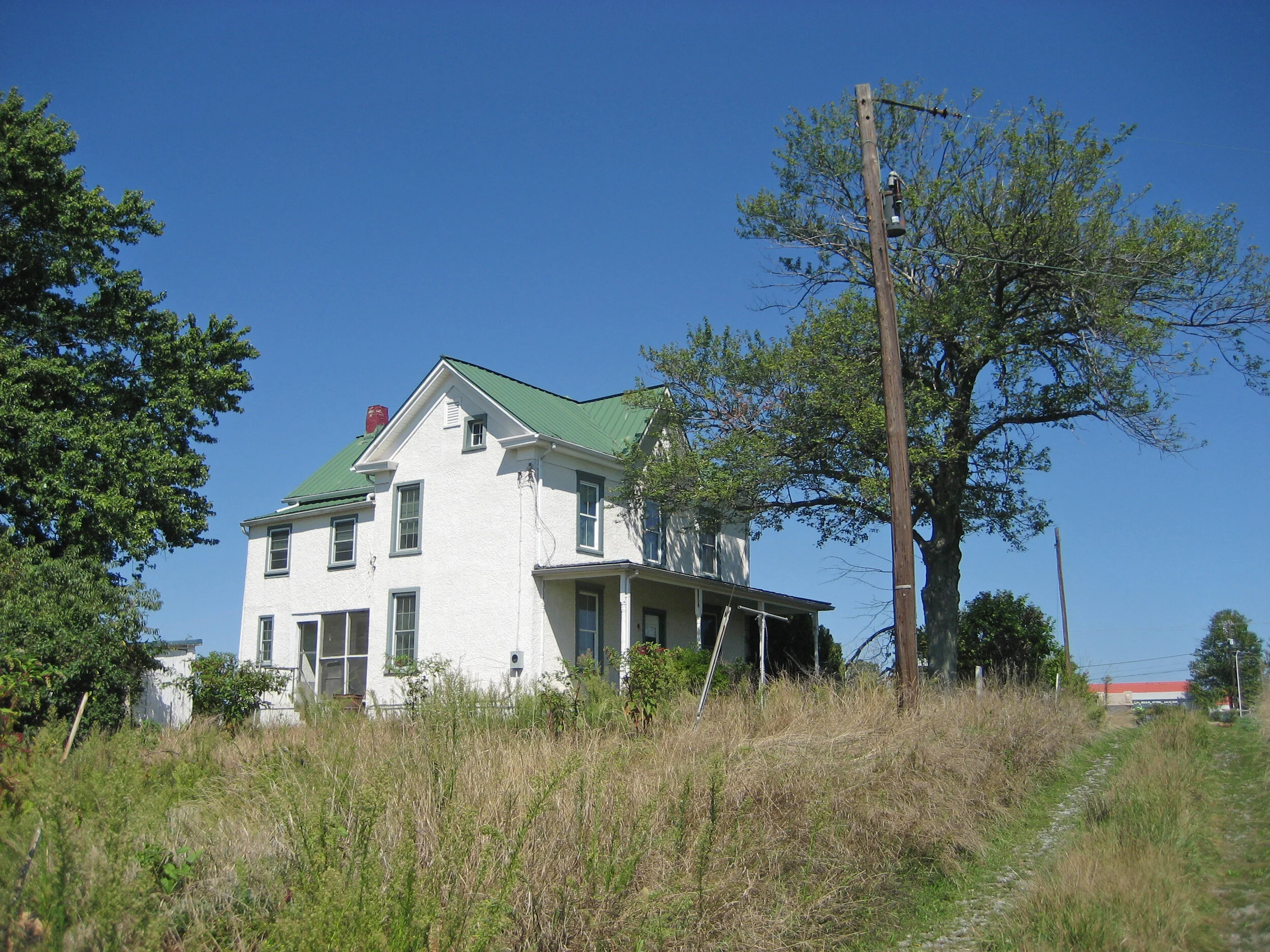
“When I showed up yesterday morning at 8 a.m. the developer was surveying the damage with the firefighters,” Curtis said. “I just hope nothing like this ever happens to the old Crown farmhouse, which was not damaged by the fire.”
The city’s elected officials were officially notified of the fire in an email sent out by a lieutenant in the city’s police department about noon on May 30.
Ossont said the fire originated on a 2-½ acre historic site, known as the farmstead, that is scheduled to be dedicated to the city in the future for a park. Other nearby buildings, including the Heeter-Crown House, log house, smoke house and small garages were not damaged in the blaze, he said.
According to Ossont, a police report was filed a few weeks ago when someone broke into the historic Crown house and he noted that the area has been a target of graffiti vandals as well.
Slow Demise of Historical Structures “Helped Along”
Imperceptible to the overworked aloof sheeple by-design, 20/20 hindsight suggests possibility of slow demise being assisted. The end-result was a land-grab and reworked to tremendously boost the tax-base. Presumably, this is being done all over the world as DEW proliferates amidst the haplessly aloof.
You’re basically describing what happened at the old England-Crown farm area (now the Crown / Downtown Crown development in Gaithersburg), with one nuance: it wasn’t just one “farmhouse burned” event. It was a mix of demolition plus fire losses during redevelopment. (The Washington Post)
What records show:
- The City’s Crown Farm project (annexed in 2006; major revised approvals in 2010) set up the large mixed-use redevelopment. ([gaithersburgmd.gov][2])
- A City-commissioned historic report says a fire on May 29, 2011 destroyed several agricultural buildings on the site.
- Reporting at the time also describes that some structures were razed and others burned as the project moved forward. (The Washington Post)
- At least part of the historic farm complex was preserved/restored (including surviving historic structures tied to today’s Crown Farm Park, such as the corn crib barn/silos). (The Washington Post)
Also, “Crown Point” in Gaithersburg can refer to other nearby properties (for example, Crown Point Corporate Center), which is separate naming from the Crown Farm/Downtown Crown redevelopment and can cause mix-ups in memory. (Robinson Development Group | RDG)
[2]: https://www.gaithersburgmd.gov/government/projects-in-the-city/crown-farm
(Past chat)(Past chat)(Past chat)(Past chat)
Yes—if you mean the Crown Farm / Downtown Crown site in Gaithersburg, that matches what happened.
The record shows this sequence:
- The tract was annexed into Gaithersburg in 2006, then purchased out of bankruptcy in Jan 2010; revised approvals were granted in Dec 2010. ([Gaithersburg][5])
- A city-commissioned historic report states a fire on May 29, 2011 destroyed several agricultural buildings on the site.
- Reporting from the 2012 groundbreaking period says a farmhouse had been demolished (with demolition permits approved) and that some other farm buildings had been razed or burned in prior years; it also notes another historic house on the property (England-Crown farmhouse) was to be restored. (The Washington Post)
- City project records show construction of the new development began in 2013. ([Gaithersburg][5])
So the short answer is: yes, historic farm structures were lost (including by fire), and the area was then redeveloped as Crown/Downtown Crown—but it was a mix of events (fire + demolition of different structures), not just one single burn event for the whole site.
[5]: https://www.gaithersburgmd.gov/government/projects-in-the-city/crown-farm
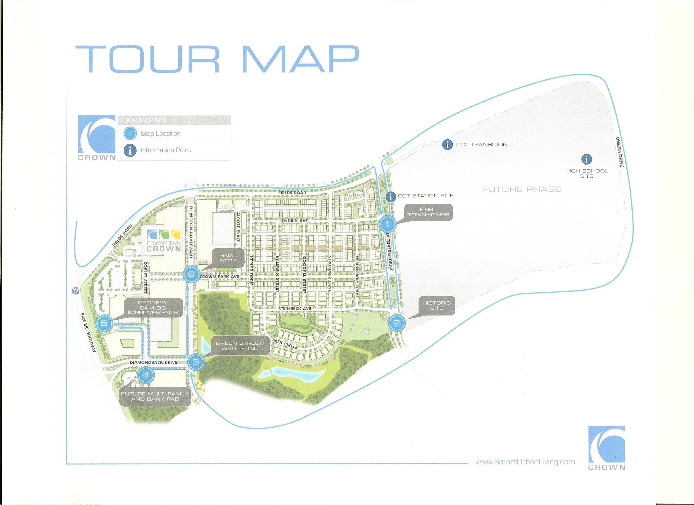
Map of the exact former farmhouse/building locations against today’s street grid in Crown (Fields Rd / Decoverly / Sam Eig) in a clean parcel-by-parcel list. (Hilariously, Sam Eig was an accomplished land developer in Montgomery County, Md. His nephew was
| Historic area / parcel context | Today’s parcel/street anchor | Former building locations (mapped to now) | Current status |
|---|---|---|---|
| Former P833 historic setting (identified as ~75.8 acres in planning materials) | Split over later Crown plats; core around Decoverly/Steinbeck | This was the farm complex concentration referenced in preservation docs | Subdivided/absorbed into Crown neighborhood fabric (Montgomery Planning Board) |
| Parcel C, Block D (plat) | Decoverly Dr / Steinbeck Ave corner; city documents reference Crown Farm Park here (403/415 Decoverly) | Surviving outbuilding cluster mapped here in renovation docs (corn crib/small barn, dairy-related structures/silos, grain bin, garage/storage set) | City park/historic resource area |
| Lot 35 (adjacent to Parcel C in reports/figures) | Immediately adjacent to same corner grid (Steinbeck/Decoverly context) | Manor House + Log House + Smoke House group shown as preserved/private in report figures | Private lot with preserved historic buildings |
| Parcel A, Block D (plat) | South/southwest of the same node, tied to Salk/Decoverly area in plat geometry | No primary farmhouse pin shown here in the renovation summary; this is largely supporting land around the historic node | Open-space/supporting parcel in the Crown subdivision pattern |
| Former Heeter-Crown farmhouse sector (outside preserved core) | “Off Fields Rd before Washingtonian entrance” (historic note); corresponds to west/northwest side of Downtown Crown plan envelope | Former farmhouse location likely within what became built mixed-use/residential blocks | Demolished pre-buildout (2010, per local historical archive) ([Gaithersburg][2]) |