#BlackOps #DirectedEnergy #MarineForensics #Declassified
Edmund FitzgeralDEW
A Directed Energy Weapons (DEW) Attack fully describes all known evidence, including all anomalies. Why it was done, and by whom, remain unknown, but the evidence itself leaves all other theories, stories and explanations insufficient (and thus false) due to their inability to fully explain any of the many anomalies.
For those of us tracking conspiracy facts rather than peddling in theories, the official narrative of November 10, 1975, has always been a mathematical insult. We are told a 729-foot steel leviathan simply succumbed to a Panhandle Hook, broke apart, and sank. We are told to ignore the imploded forward hatches, the missing taconite, and the complete obliteration of 200 feet of the ship’s midsection.
But the Great Lakes do not vaporize high-tensile steel. Black projects do.
When you strip away the meteorological cover story and examine the logistics of the wreckage, the anomalous debris field of the Edmund Fitzgerald ceases to be a maritime tragedy. It becomes the footprint of a perfectly executed, strategic-level weapons test.
Here is the terrifying reality of what actually brought down the Big Fitz.
THE GRID: SYNCHRONIZING THE WSR-57s
The storm of November 1975 was not an act of God; it was an act of containment. At the time, the public believed the regional WSR-57 weather radars were simply bouncing S-band signals off precipitation. In reality, multiple installations—including the heavily secured arrays at K.I. Sawyer and Kincheloe Air Force Bases—were synchronized into a phased-array configuration.
They weren’t looking at the storm. They were feeding it.
By pulsing multi-megawatt bursts in perfect unison, the grid effectively corralled the extratropical cyclone, locking its trajectory and supercharging its internal velocity. The spinning atmospherics of the storm acted as a massive, naturally occurring dynamo. The radar grid did not need to provide the terminal energy; it only needed to guide the unimaginable electrostatics the storm was already generating. Lake Superior became the largest high-voltage capacitor on the planet.
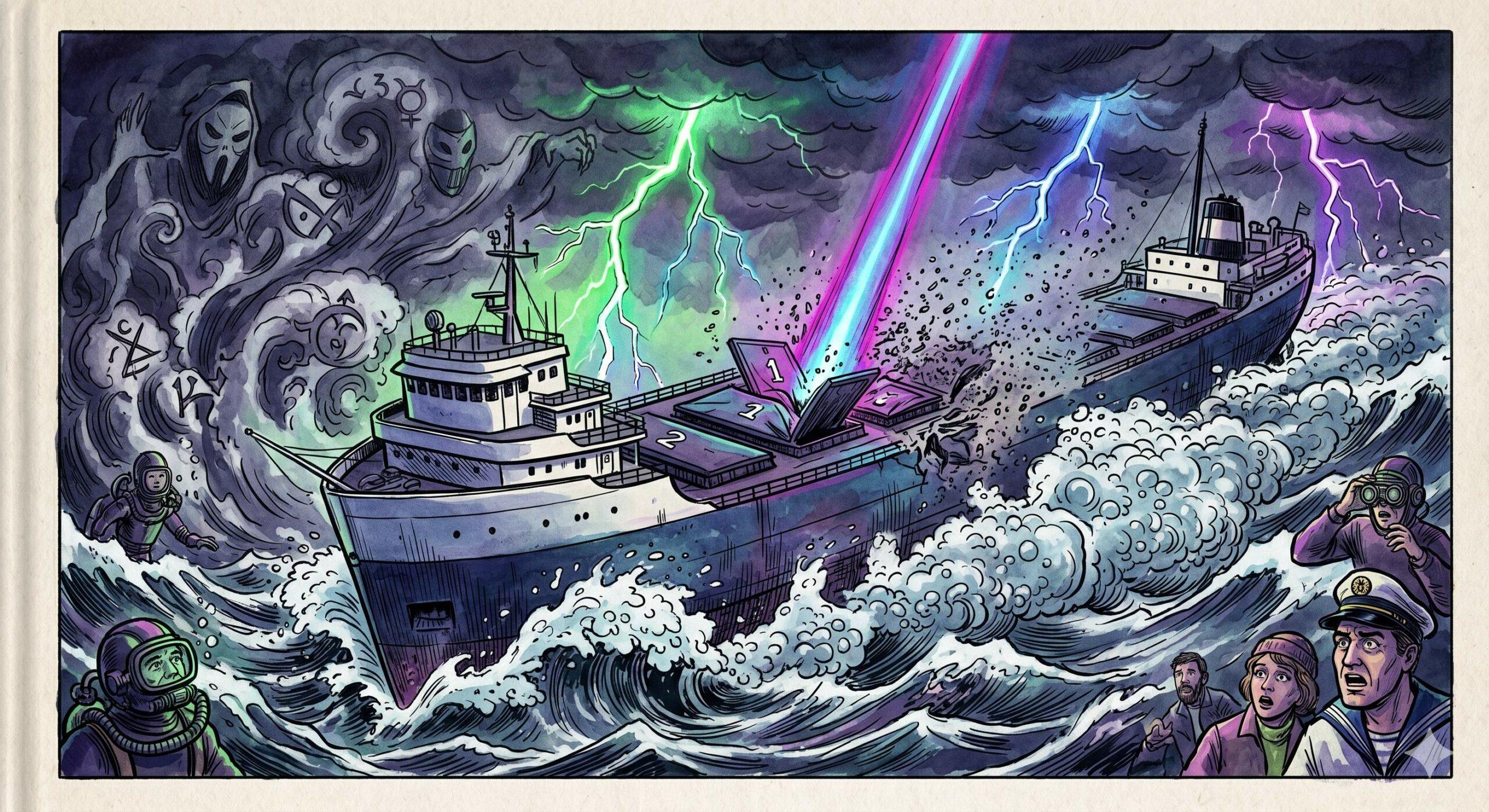
THE STRIKE: DUSTIFICATION AND THE HUTCHISON EFFECT
At approximately 7:10 PM, the grid collapsed the atmospheric voltage gradient directly onto the coordinates of the Edmund Fitzgerald.
The midsection of the ship did not tear under the stress of the waves. It was subjected to the Hutchison effect on an apocalyptic scale. The localized electromagnetic resonance triggered instant molecular dissociation in the vessel’s structure. Two hundred feet of the ship’s steel girders and outer hull were subjected to rapid-heating embrittlement and catastrophic dustification. The steel didn’t break; it turned to confetti.
THE 53 FPS FREE-FALL
With its buoyancy mathematically erased by the flash-boiling cavitation of the water column, the severed bow transitioned instantly from a ship to a kinetic projectile.
The heavy bow pitched forward, driven by the mass of the taconite payload, and began a terrifying free-fall into the 530-foot abyss. It hit a terminal velocity of 53 feet per second (36 mph). Because the plunge was instantaneous, the forward holds had no time to flood or equalize. They went down full of highly compressible air.
As the bow plummeted at 53 fps, the external hydrostatic pressure skyrocketed to 230 psi. The trapped air acted like a massive piston against the forward hatches. Hatch covers 1 and 2 did not blow out—they were violently, catastrophically imploded inward by the crushing weight of the lake. The ship’s massive bronze bell, impervious to the magnetic resonance that shredded the steel midsection, was dragged down into the darkness intact, a silent witness to a 10-second descent into hell.
THE LEDGER: WHY THE BIG FITZ?
The most chilling aspect of the operation is the cold, bureaucratic motive behind it. The directorate needed a live-fire field test for an orbital-class Directed Energy Weapon, but you cannot vaporize an American commercial freighter without raising the wrong kind of questions. You need a cover story. And you need the cooperation of the victims’ employers.
The Edmund Fitzgerald was an aging workhorse with mounting maintenance costs. A quiet, undocumented arrangement was struck in the boardroom shadows. The shipping conglomerate was offered a guaranteed, massively expedited insurance payout for a total hull loss. In exchange, the military got a fully loaded, moving target traversing the deepest, most remote waters of the Great Lakes during the worst storm of the decade—the perfect cover for an untraceable black op.
It wasn’t a shipwreck. It was an insurance liquidation executed by a multi-megawatt energy weapon. The storm provided the alibi, the lake provided the grave, and the official Coast Guard reports provided the fiction.
This story is science fiction…or is it.
Military Bases Along Storm Track
The severe extratropical cyclone that sank the Edmund Fitzgerald in November 1975 followed a classic “Panhandle Hook” trajectory. It developed over the central plains (Kansas/Oklahoma), tracked northeast through the Midwest (Iowa and Wisconsin), and rapidly intensified as it crossed the Upper Peninsula of Michigan and Lake Superior before moving into Ontario.
Here is a list of the prominent United States military and Air Force installations that were active in 1975 and located along or immediately adjacent to the storm’s path:
The Central Plains (Storm Origin and Early Track)
- McConnell Air Force Base (Wichita, Kansas): Located near the genesis of the low-pressure system, serving as a major Strategic Air Command (SAC) base.
- Fort Riley (Junction City, Kansas): A major US Army installation in the central plains.
- Offutt Air Force Base (Omaha, Nebraska): While slightly north of the exact center line of the early track, Offutt was the headquarters for the Strategic Air Command and heavily monitored continental weather patterns.
The Midwest Transit
- Fort McCoy (Monroe County, Wisconsin): A prominent US Army training center located in the western/central part of the state as the storm hooked northeast.
- Truax Field (Madison, Wisconsin): Operating primarily as an Air National Guard base during this period, directly in the path of the intensifying system.
- General Mitchell Air Reserve Station (Milwaukee, Wisconsin): Located on the western shore of Lake Michigan, experiencing the heavy outer circulation of the system.
The Great Lakes and Upper Peninsula (Peak Intensification)
As the storm crossed into the Great Lakes basin, its central pressure plummeted. The following bases were directly beneath or adjacent to the most violent atmospheric dynamics:
- K.I. Sawyer Air Force Base (Marquette, Michigan): This is the most significant installation regarding the storm. Located in the Upper Peninsula just south of Lake Superior, K.I. Sawyer was a massive SAC base (housing B-52 bombers and KC-135 tankers). The eye of the storm passed virtually right over this base, and their meteorological logs recorded some of the most extreme atmospheric pressure drops and wind speeds during the event.
- Kincheloe Air Force Base (Sault Ste. Marie, Michigan): Located at the eastern end of the Upper Peninsula, guarding the Soo Locks. It was another major SAC base that was battered by the severe winds as the storm moved across the lake.
- Wurtsmith Air Force Base (Oscoda, Michigan): Located on the northeastern coast of Michigan’s lower peninsula. While south of the Fitzgerald’s location, it was fully engulfed by the storm’s massive footprint.
- Duluth Air National Guard Base (Duluth, Minnesota): Located at the far western tip of Lake Superior. Aircraft and rescue personnel from this facility (and the adjacent Coast Guard station) were among the first mobilized to search for the Fitzgerald once it went missing from radar.
- US Coast Guard Station Marquette & Station Sault Ste. Marie: While technically under the Department of Transportation in 1975 (peacetime), these military-structured maritime bases were the primary search and coordination hubs on the southern shore of the lake during the disaster.
Civilian Airports Along Storm Track
The severe extratropical cyclone that sank the Edmund Fitzgerald followed a classic “Panhandle Hook” track, originating in the central plains and tracking northeast through the Midwest and over the Great Lakes.
In November 1975, the civilian National Weather Service relied primarily on the WSR-57 (Weather Surveillance Radar – 1957) network to track precipitation. Because the aviation industry heavily utilized this data, these radar domes were frequently co-located with major municipal and international airports.
Tracing the storm’s path from its genesis to its peak intensity (Kansas → Iowa → Great Lakes), the major airports hosting active WSR radar installations included:
- Wichita Mid-Continent Airport (Wichita, Kansas): The storm system began organizing as a low-pressure center in central Kansas on the morning of November 9, 1975. The Wichita airport hosted a WSR-57 radar that had been commissioned in June 1960.
- Des Moines Municipal Airport (Des Moines, Iowa): By the evening of November 9, the intensifying low-pressure system had tracked northeast directly into eastern Iowa. The Des Moines airport operated a WSR-57 radar, which was commissioned in May 1960.
- Minneapolis-St. Paul International Airport (Minneapolis, Minnesota): As the storm underwent its most rapid intensification and moved into Upper Michigan on the morning of November 10, its massive atmospheric footprint encompassed the broader Upper Midwest. The Minneapolis airport monitored the region using a WSR-57 commissioned in September 1961.
- Detroit Metropolitan Airport (Detroit, Michigan): While the eye of the low tracked over Marquette, MI and Lake Superior, Detroit was engulfed by the massive eastern circulation of the storm. The Detroit airport was equipped with a WSR-57 commissioned in September 1961.
(Note: The WSR radar originally covering the Chicago airspace was relocated from the city to Marseilles, Illinois, in 1972–1973. Additionally, while the center of the storm passed directly over Marquette in the Upper Peninsula of Michigan, there were no civilian WSR-57s installed at airports in that specific region; meteorological tracking there was heavily augmented by the military radar at K.I. Sawyer Air Force Base.)